
A podcast for geospatial people. Weekly episodes that focus on the tech, trends, tools, and stories from the geospatial world. Interviews with the people that are shaping the future of GIS, geospatial as well as practitioners working in the geo industry. This is a podcast for the GIS and geospatial community subscribe or visit https://mapscaping.com to learn more
Episodes
Thursday Feb 04, 2021
Thursday Feb 04, 2021
This week I am joined by Todd Barr, here are a few of the topics that come up during the conversation.
- SQL and confidence are must-have skills
- Mentors, champions, and superheroes
- Diversity in the geospatial community
Sponsored by Picterra
Guide to Earth Observation data and satellite imagery sources
Remember to Subscribe :)
Share this podcast with a friend!
Join the email list
https://mapscaping.com/podcast
Happy to connect with you on LinkedIn
Thursday Jan 28, 2021
Thursday Jan 28, 2021
Previously, with only one constellation and GPS, you could see perhaps two or three satellites and quickly lose the positioning within the city. This is now rare to see in devices that do not support multi constellations. Plus, all the constellations are built to be compatible with each other — all the receivers that can see multiple constellations can compute the position using the different satellites
Remember to Subscribe :)
Share this podcast with a friend!
Join the email list
https://mapscaping.com/podcast
Happy to connect with you on LinkedIn
Thursday Jan 21, 2021
Thursday Jan 21, 2021
Knowing the depth and shape of the seafloor (bathymetry) is fundamental for understanding ocean circulation, tides, tsunami forecasting, fishing resources, sediment transport, environmental change, underwater geo-hazards, infrastructure construction and maintenance, and much more.
Despite many years of effort, less than 20 percent of the world ocean's seafloor has been mapped.
Thanks to Commander Samuel Greenaway - National Oceanic and Atmospheric Administration ( NOAA)
https://seabed2030.org/
This episode was sponsored by Picterra
Remember to Subscribe :)
Share this podcast with a friend!
Join the email list
https://mapscaping.com/podcast
Happy to connect with you on LinkedIn
Thursday Jan 14, 2021
Thursday Jan 14, 2021
Sarah Taigel, a professional geographer shares some insight into what a career path might look like, some of the pivots she has made along the way from developing GIS products and services to working as a geographer and interfacing with stakeholders.
The SlowWays project https://slowways.uk/
Remember to Subscribe :)
Share this podcast with a friend!
Join the email list
https://mapscaping.com/podcast
Happy to connect with you on LinkedIn
Thursday Jan 07, 2021
Thursday Jan 07, 2021
Augmented reality (AR) is an interactive experience where the objects that reside in the real world are enhanced by computer-generated perceptual information.
Remember to Subscribe :)
Share this podcast with a friend!
Join the email list
https://mapscaping.com/podcast
Happy to connect with you on LinkedIn
Wednesday Dec 16, 2020
Wednesday Dec 16, 2020
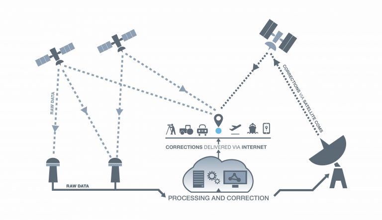
Satellite-based Augmentation System or SBAS can augment standalone Global Navigation Satellite Systems such as GPS in a number of areas including accuracy, integrity, and availability.
It works by collecting raw positioning data from Continuously Operating Reference Stations (CORS) in the region, computing error corrections and disseminating these corrections to users from a geostationary communications satellite via an uplink ground station.
Precise Positioning Outreach for Australia and New Zealand
https://www.ga.gov.au/news-events/news/latest-news/pinpointing-the-uses-of-precise-positioning
Remember to Subscribe :)
Share this podcast with a friend!
Join the email list
https://mapscaping.com/podcast
Happy to connect with you on LinkedIn
Friday Dec 11, 2020
Friday Dec 11, 2020
OpenLayers makes it easy to put a dynamic map on any web page. It can display map tiles, vector data, and markers loaded from any source.
"The web is the future of programming and the web is built on HTML, HTML has one first-class programming language JavaScript"
Remember to Subscribe :)
Share this podcast with a friend!
Join the email list
https://mapscaping.com/podcast
Happy to connect with you on LinkedIn
Thursday Dec 03, 2020
Thursday Dec 03, 2020
Remember to Subscribe :)
Share this podcast with a friend!
Join the email list
https://mapscaping.com/podcast
Happy to connect with you on LinkedIn
Wednesday Nov 25, 2020
Wednesday Nov 25, 2020
GRASS GIS is one of the few vector topology engines out there, it can handle volumetric raster data ( Voxels), 3d vector data, works in a variety of ecosystems, GRASS functionality is accessible via a range of interfaces ... and completely free!
GRASS GIS https://grass.osgeo.org/
Thanks, Markus!
https://twitter.com/MarkusNeteler
Remember to Subscribe :)
Share this podcast with a friend!
Join the email list
https://mapscaping.com/podcast
Happy to connect with you on LinkedIn
Thursday Nov 19, 2020
Thursday Nov 19, 2020
Train your own AI to detect objects and patterns on satellite and aerial imagery. This might just change the way you think about WMS services ;)
500 free credits! https://picterra.ch/mapscaping/
Also mentioned in this episode https://mapproxy.org/
MapProxy is an open-source proxy for geospatial data. It caches, accelerates and transforms data from existing map services and serves any desktop or web GIS client.
Remember to Subscribe :)
Share this podcast with a friend!
Join the email list
https://mapscaping.com/podcast
Happy to connect with you on LinkedIn